

Features DCS Nav
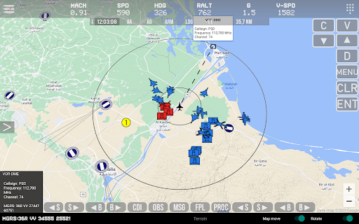
For working You need to download and install Lua export script for DCS World from here:https://github.com/pet333r/pw-dev_scriptDetailed information on how to add a script to DCS World can be found on the same pagemain functions:- displaying your own position and data (metric / imperial)- NS430 support- displaying the radius of a circle around the user module- displaying the position of other objects: airplanes, helicopters, ships- displaying Morse code of object identifiers on the map- SAM launcher position display- displaying information about current missiles in the air- displaying airports on the map with information- displaying parkings at airports- display of available ILS tracks with navigation information- display beacons (TACAN, NDB, VOR etc)- displaying different icons depending on the type of object- displaying map boundaries- displaying NTTR boundaries- displaying the line between the user and the selected object along with the current distance- display of additional information (A/A, A/G, Arm, landing gear, distance to selected object)- radio altitude limit warning- change of frequency of data reception from DCS World for individual objects- ability to enable/disable displaying individual objects on the map- option to add waypoints on the map (up to 5)- change of map type- display of GPS data in the following standards: DD / DMS / MGRS- side menu with the ability to quickly change the display of objects on the map- support for DCS Util app- works with any module
Secure & Private
Your data is protected with industry-leading security protocols.
24/7 Support
Our dedicated support team is always ready to help you.
Personalization
Customize the app to match your preferences and workflow.
See the DCS Nav in Action


Get the App Today
Available for Android 8.0 and above